Hillery Powers
Hillery Powers is an independent muralist and hand lettering artist based in Denver, Colorado. Much of her work is place-based and showcases the locations, landmarks, and neighborhoods that people call home or love to visit.
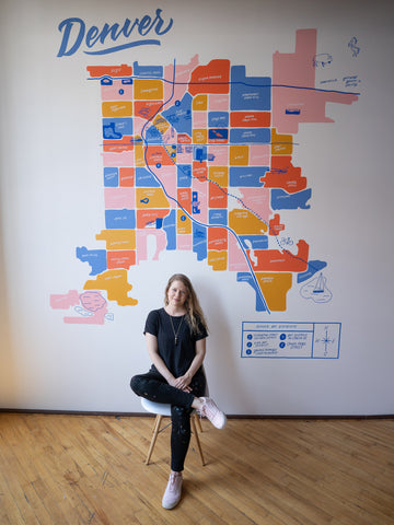
Hillery describes her journey to create the Denver Neighborhoods Map mural:
"I've been working on a colorful map of Denver Neighborhoods for a while now, and decided to paint it on a wall of my shared studio space in the Dry Ice Factory located in Five Points, Denver. Many would say my office is actually in the RiNo Art District—it is. But the technical city-defined neighborhood is Five Points.
I spent a lot of time researching mapping data. I started with the Denver.gov neighborhoods map, and made a few artistic decisions. For example, most Denver maps you see draw the line of the city at Stapleton in the northwest—leaving out Montbello, Gateway/Green Valley Ranch (which were annexed to Denver in the 60's/70's, so they're late additions to the city), and DIA. I hated to follow this trend and leave out actual defined neighborhoods, but I saw that other artists had a reason—those 3 neighborhoods are huge and alter the known square-ish 'shape of Denver', and as much as I wanted to include them it just wouldn't work for the wall layout. So I labeled them with an arrow and drew a little Blucifer representing the airport.
The rest of my map data came from OpenStreetMap, Google Maps, and more Denver.gov maps, including a Parks & Rec map. From there, I began laying out the neighborhoods with a hand drawn feel and adding a few key roads (I-70, I-25, and Colfax). I labeled each official city neighborhood white, added in a few colloquial names in blue, and numbered the 5 art districts within city limits with labels in the map legend.
Last were the illustrations—I included landmarks Denver is known for (Union Station, the Big Blue Bear at the Convention Center, Coors Field, etc.) and some iconic parks (Cheesman Park with the Denver Botanic Gardens, City Park with the Denver Zoo, Washington Park with its flower gardens.) My final addition was the Cherry Creek Trail, which runs diagonally through nearly the entire city and gives pedestrians and cyclists a beautiful view of Denver."
Learn more about artist Hillery Powers and shop the Denver Neighborhood Map Print available through History Colorado!